History Of
The Bush Camp
The history of the area around our Camp
The history of the area around our Camp
Take in the scenery of villages and lush rice fields nestled among the mountains of Chiang Mai province during the 1.5h drive from the airport or Chiang Mai town. Our comfortable, airconditioned minivans are driven by our friendly, skillful drivers who are there to ensure a smooth transfer to The Bush Camp.
Enjoy lunch at our restaurant overlooking the Ping river and a stunning backdrop of mountains as far as the eye can see. After the hearty lunch consisting of a selection of Thai and Western favorites, check into your spacious African style safari tent, decorated Northern style with hand-crafted furniture that is locally made with sustainability in mind. At The Bush Camp the amazing nature is always close by, but it can be enjoyed from a safe distance, at the comfort of your traditional safari tent that comes with a fan and an en-suite bathroom with hot and cold water shower.
Meet our free-roaming elephants and learn about this prestigious species that holds a great importance in Thai culture today and throughout the history. Our elephant exhibition sheds light on the Asian Elephant’s life cycle, nutrition, anatomy, as well as its major role in historic events over the centuries. Enjoy a delightful cup of coffee at our café overlooking the elephants roaming in a tranquil valley and help preparing one of their daily feeds.
Sit back and admire the magical sunset at your tent balcony, while listening to the cicadas starting their evening concert as the sky begins to dim. You can also dip into the infinity pool, relax, and sip a refreshing cocktail as the sun is slowly sinking down behind the mountains. Then it’s time for a delicious dinner at the restaurant overlooking the Ping river. Spend the late evening chatting with your loved ones and like-minded travelers or get carried away in another round of Jenga.
Mr. Sayan Prishanchit, archaeologist of the department for fine arts, made an interesting find discovering a grave from the bronze age.
Together with Dr. Marielle Santoni and Dr. Jean Pierre Pautrean, archaeologists from France, they created a joint Thai-French project in February 1985 to showcase the excavations.
The grave is elongated in form and in total 2 meters long, 0.85 meters wide and approximately 0.4-0.5 meters deep.
It contains an incomplete skeleton of a young adult with 32 teeth, an arm and leg bones, while the rest of the body has disappeared.
On both sides of the body, attached to the arm bones, the scientists found bracelets made of bronze- a total of 9 bracelets on the left and 5 on the right side.
Additionally, lower on the body, two bended and broken bronze bracelets were discovered.
Interestingly, each side of the body also has a bracelet made of seashells attached and close to the corpse a string of beads made of seashells and Carnelian stones were found.
In the lower part of the grave, near the position of the feet, a large quantity of broken pottery like vases and bowls were scattered around.
The grave and skeleton are archaeological and historically important for North-Thailand. At present the findings are displayed in the National Museum in Chiang Mai.
From the late stone age, some 28,000 years ago, until into the metal age, the area around Pa Chang Cliff was a camp and ceremony site for nomadic groups of hunters-gatherers.
Besides his work on the graves mentioned above, in 1983 Mr.Sayan Prishanchit, discovered several ancient wall paintings and utensils made of stone in the area.
Together with the two French archeologists Dr. Marielle Santoni and Dr. Jean Pierre Pautrean he started another joint Thai-French project and during the excavations in 1986 more evidence of the hunter-gatherers were found in the area of Pa Chang.
The findings consisted mainly of stone tools and a large amount of animal bones estimated to be from the middle stone age.
Carbon test on the animal bones revealed, that the first group of nomads lived here about 28,000 years ago, which makes this site one of the oldest archeological sites found in the north of Thailand.
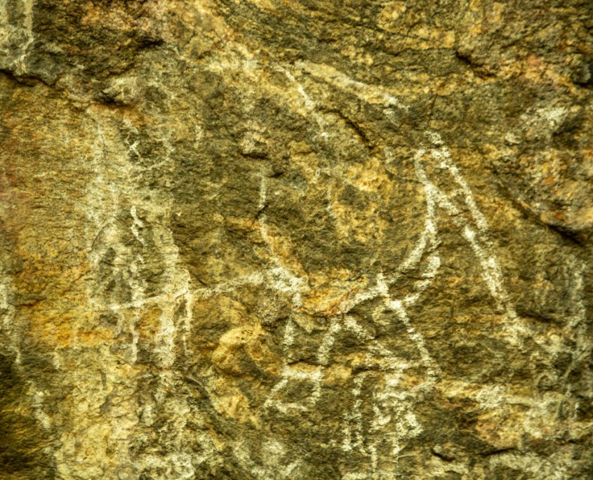
The wall paintings at the Pa Chang cliff are dated back to 2,500-3,000 years ago and show an elephant, a person and many other symbols, confirming its use as a ceremonial site.
All the excavations are at present displayed at the National museum in Chiangmai.
There are 2 types of water sources, surface water sources, and groundwater sources. Ob Luang water source is an underground type caused by dehydration of tree roots and continues flowing into the river.
About 100 years ago Mae Cahm river was the most convenient way to transport logs to the Ping river and to Bangkok. The logs were kept in a pond, made by a wall built in the water. When the water level rose in the rainy season the logs were swep down over the river- an easy way to transport.
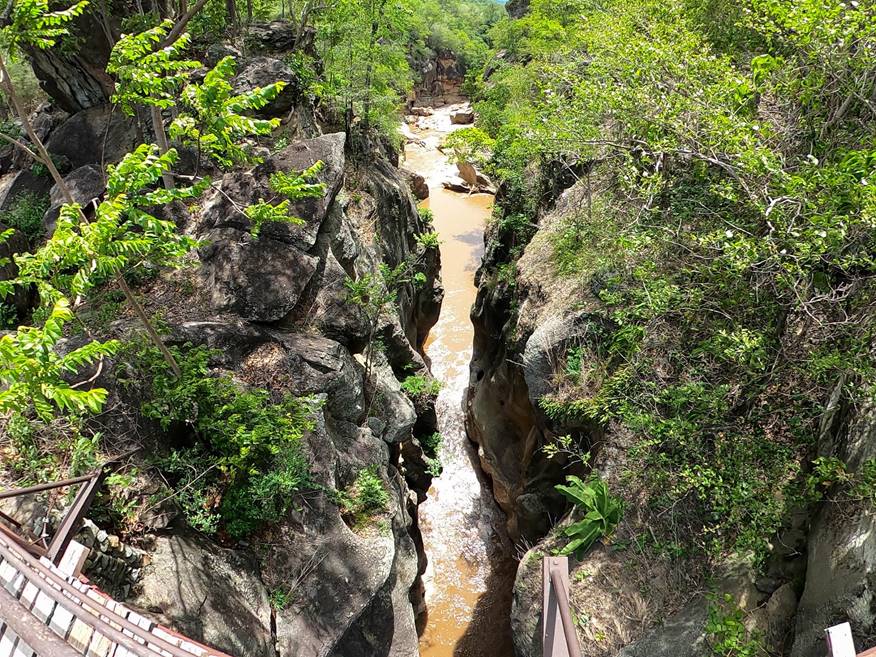
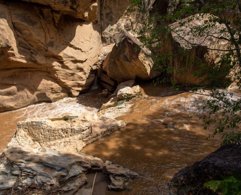
The Ob Luang gorge or canyon is located 17 kilometers of highway number 108 just of Hod and Jomthong district. It is a steep sided canyon with high cliffs. The height of the canyon’s wall measured from the bridge to the average water level is about 32 meters. The narrowest point of the canyon is not more than 2 meters wide while the whole canyon is about 300 meters in length.
The source of the Mae Chaem or Salak Hin River is located in Mae Hong Son Province. The Mae Chaem river is the biggest tributary of Hod district and drains its water eventually in the Mae Ping River. The river passes steep cliffs, knolls, valleys and has some islands and sandy beaches. The diversity of landscapes gives the river an extra beautiful dimension.
The Mae Chon Luang streams from the Mae Chon waterfall located 9 kilometers of highway number 108 between Hod and Mae Sariang district.
You can follow the stream for about one kilometer from the road until you reach this impressive and high waterfall.
The tiered falls have a sheer drop of over 100 meters and are 80 meters wide which makes it a fascinating sight.
The cliffs and rocks of these falls are composed of granite and grey-white colored metamorphic rock. There are 2 small waterfalls, 500 meters and 1500 meters from there.
The Thep Phanom hot springs are a 14 kilometers ride from Ob Luang, along highway 108. From this point it is another 9 kilometers to the springs. The cold water in the earth crust is heated up by the thermal energy of the earth and, it doesn’t cool down until it’s released at the surface. The spring area consists of a 1.6-hectare plateau and several small streams with both warm and cold water. There are a total of 15 springs with a streamflow not less than 15 liters per second. The average temperature of the water is 99 degree celsius.
Ob Luang has a large area and a great altitude range. Therefore different types of forest can be found.
These forests occur on an elevation below 800 meters above sea level and are divided into below.
1.1 Dry Dipterocarp Forest
These are open forests mostly occurring on dry and poor soils like the name indicates. The soil is rocky making it difficult for trees to grow. The forest is mostly composed of medium to big sized trees.
Ob Luang National Park is covered with this type of forest and the most common trees species are Dipterocarpus obtusifolius, D.tuberculatus, Shorea obtusa,. S.siamensis and Phyllanthus emblica.
The forest floor is mostly covered with Arundinaria pusilla grass and many species of Bamboo are abundant.
1.2 Mixed Deciduous Forest
This is an open, less dry forest and contains some extraordinary plants.
It occurs mostly along stream and water courses.
Typical species are Tectona grandis(Teak), Pterocarpus macrocarpus, Xylia xylocarpa, Afzelia xylocarpa, Dalbergia dongniensis, D.assamica, Millettia sp., Lagerstroemia sp., Terminalia alata and Diospyros mollis.
The forest floor is covered with grass and different species like Bambusa arundinacea, B.tulda, Dendrocalamus strictus, Thyrsostachys siamensis and Oxytenanthera albociliata.
2.1 Dry Evergreen Forest
This type of forest can be found on hillsides and valleys mostly on wetter sites, it’s a rice forest type and contains species like Dipterocarpus sp., Hopea sp., Afzelia xylocarpa and Stereospermum personatum.
2.2 Hill Evergreen Forest
Occurs on higher elevations and wetter sites. It is sometimes mixed with Pine forest and is scarce in Ob luang. Common species are Castanopsis acuminatissima, C.diversifolia, Lithocarpus garrettianus, Ghalotaxus griffithii, Cedrela toona, Eugenia sp. And Magnalia henryi. Ferns, orchids, mosses and herbs are abundant.
2.3 Pine Forest
Occurs between 800-1000 meters above sea level range. In Ob Luang it can be found at Doi Pa Kluay, Doi Pa Dam, Doi Kham, Doi Mu Ting and Doi Pui Luang. Both the two-leafed (Pinus merkusii) and three-leafed (P.kesiya) pine occur. The forest floor in this forest type is mostly grassy.
The wide variety of habitats promises wide variety of wildlife. But due to hunting pressure large mammals mostly disappeared and overall wildlife is not as rich as it used to be. Still some interesting wildlife can be seen such as Serow, Tiger, Asiatic Black Bear, Civets, Barking Deer, Sambar Deer, Wild Pig, Gibbon and many species of birds.
As history describes the part of the past known from texts or inscriptions, prehistory includes all the periods of the past before history and without written proof.
During prehistory, the first communities were formed and slowly maturated, through different phases of evolution.
Sometimes this included changes in population, to become the historical, and later on, modern societies of today.
The ground of contemporary cultures of Thailand are to be found in its prehistoric past, which we have to study to get a better understanding of our environment and of our society.
Since there are no texts, the only way to gain knowledge of prehistory is through archaeological excavations.
The inhabitants of prehistoric settlements have left behind many remains, now buried under the soil and vegetation.
To retrieve these remains allows us to reconstruct tentatively, through interpretation, the everyday life of prehistoric people, their technology and its evolution, their influence upon the environment, and enables us to have an idea of the size and structures of their social groups.
The first step is the field survey, which enables us to locate and identify archaeological sites from surface remains such as potsherds or stone tools.
The next step is the excavation, which must be conducted extremely carefully, by successive scrapings of the levels.
The objects themselves, their relative position and distribution in the past is important.
Horizontally, the traces of structures and the concentration of a particular type of remains can provide information about the areas of habitation and of specialized craft activities.
Vertically, a section made through the occupational levels (stratigraphic section) will give evidence of chronological succession.
Recording the data has to be done very precisely and scientifically: the archaeologist, using photographs, drawings, and depth measurements, must represent every object or feature in its exact position in three dimensions for a later reconstruction.
Excavation is quite a destructive activity with no return, “like a book, the pages of which one would tear off as reading along”.
The stratigraphy be carefully mapped, in order to represent each level in chronological succession.
Then the remains themselves must be studied through photography, drawing, classification, scientific analysis, which will allow comparisons, dating and a reconstruction of the technology, the way of life, the environment, etc.
Finally, the results and synthesis of such research will be offered to the public through books and exhibitions.
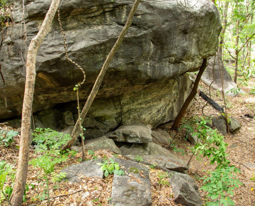
Pha Chang, the Elephant Shelter, is situated above the gorge, on the left bank of the river, below a huge rounded rock, which emerges above the forest and can be seen from some distance. It could be easily spotted by the nomadic groups of hunter-gatherers of the Mesolithic period.
They would stay there temporarily leaving many remains.
The excavation revealed- through two meters of anthropic deposit- several occupational floors, unfortunately partly disturbed by a subterranean water erosion.
The excavated remains (broken/crushed animal bones, cobbles, natural pebbles, flaked pebble tools, pieces of hematite), can help us to reconstruct the daily life of these nomads.
Under the shelter, they would sleep, eat, and make tools from quartzite pebbles gathered from the bed of the nearby rivers, or sometimes, blocks of jasper and rock-crystal picked up when travelling.
They would hunt various species of deer, large bovines, and wild pig, which they would eat, as well as fish, tortoises and snails.
All the bone remains were found broken or crushed. They would probably also gather various vegetable foods, berries, roots or similar.
One can still find evidence of their presence on both sides of the river:
Pebble tools left behind during their expeditions, or after having achieved their task. The vegetation was all that time probably much denser than nowadays.
On the wall of the shelter, they left some paintings, made with red pigment (hematite), but these were unfortunately worn off and obliterated by later white paintings (possibly made during the Neolithic period) representing elephants, various animals, and some human shapes.
From ethnological comparisons, and experimental reconstructions of lithic technology, it is generally assumed that the time devoted to “work” (making of the tools, hunting, gathering, cooking) was quite minimal, averaging three or four hours a day. The rest of the time, they would just enjoy life. The movements of the groups, several times per year, according to their needs, were irregular, and the time spent in one place could vary from a few days to several months.
A small farming community settled on the right bank of the Mae Chaem River, near
the slope of the hill, maybe more than 3000 years ago.
Of the occupation, only a small mound is left. Three soundings enable us to recognize several occupational floors, defined by crushed pots, polished stone tools and flakes, animal bones, and various remains. The habitation structures, most probably of wood and bamboo, did not leave any trace.
The inhabitants of Ob Luang had by that time already domesticated dogs, pigs, and most likely buffalos, but their diet largely consisted of game (various species of deer) as well as fish, crabs, and tortoises from the river. Agriculture was probably practiced, but no vegetal remains have been preserved.
The hand-made pottery consists mostly of round bottomed and cord-marked globular jars, of various size, used as cooking pots or water containers, and of more elaborate vases, for other functions: graceful jars with carinated shoulders, sometimes decorated with incised designs and deep bowls, carinated, sometimes very fine, black and polished, the shape and colour reminding of metal containers.
Stone tools were mostly small axe-adzes, cut from a blackish rock, and polished. These polished axes were probably imported from the place where they were made, and where the raw material could be found – possibly Mae Chaem.
They were certainly precious for the Ob Luang people, since they have been resharpened, reflaked many times, and reused as small scrapers, until only the core was left. But they were apparently never repolished. Some rough pebble tools were also occasionally used. Also found were some sandstone polishers and part of a perforated stone.
Other tools, besides those made out of vegetal matter, which have disappeared, were carved out of bone: a very fine spatula, some points, gouges, maybe a spoon, and a very finely carved fishhook.
The Ob Luang villagers have left only fragments of their ornamentation behind: terracotta, shell, or ivory bracelets, a few lost beads of stone or shell. Many potsherds have been carved into circular-shaped tokens, maybe for some game.
The excavation at Ob Luang-Village provides a picture of a quite sedentary community, small but not isolated, likely to practice agriculture, but still subsisting upon the natural resources of the forest and the river. They may have produced some goods, like pottery, but had to import some others. The situation of the village, on a natural communication route, would probably stimulate commercial relations with neighbouring areas.
No metal remains were found on the village site. It was abandoned by the inhabitants who moved to another place, not far away.
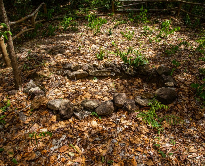
They still buried their dead in the vicinity, as evidenced by a sepulture, situated about a hundred meters down the rock shelter.
The oval pit (1m X 2m) was not very deep at discovery time, because of erosion.
Many potsherds were spread on the surface. The skeleton was in poor condition: only the shaft of the long bones and the thirty-two teeth were left.
The dead was the young adult, lying on his or her back, having a necklace of discoid shell beads, plus a carnelian bead; on the right arm were five bronze bracelets and one shell bracelet.
On the left arm, nine bronze bracelets, maybe reused as clothing fasteners, or maybe intentionally broken.
The shell bracelets are carved out of a marine conch shell; they were probably imported, and precious enough to be carefully mended when broken.
Near the feet of the skeleton was a large quantity of pottery, also broken : at least fourteen vases, mainly pedestaled bowls, three globular or carinated vases with high necks, and two or three small vases.
They all bear cord-marks, and sometimes also decorative incisions. The pottery seems wheel thrown.
Not far from the grave a complete polished stone axe and some fragments were found, which may belong to the funerary goods from this grave.
The sepulture seems to be isolated, but here and there, on the slopes of the hills, other fragments of pottery and bronze were found- maybe from other graves destroyed by erosion.
From 1985-1989, The T.F.P.R.P conducted archaeological surveys, especially around Ob Luang, in order to try to link its successive occupations with other related sites, and thus to reconstruct the prehistoric settlement pattern of the area.
They discovered several deposits of the “ Hoabinhian type”, among which were two significant ones, offering huge concentrations of pebble tools and flakes. Unlike Ob Luang, these are open-air sites.
Thephanom Hot Springs (12 Km from Ob Luang on the road to Mae Chaem)
As the name tells us, in this area hot springs (99 degrees) are found. Such a natural phenomenon of course attracted the attention of the hunter-gatherer groups, although the site, unsuitable for agricultural purposes, was apparently not occupied after them. On the surface many pebble tools of a type similar to those at Ob Luang are spread. The springs are now part of the Ob Luang National Park, open to visitors.
Ban Sarapi (13 Km. south of Hod as the crow flies)
This open-air site, which extends over one or two kilometers on eroded terraces bordering smaller streamers, is situated on a loop of the river Ping, not far from the new village of Ban Sarapi, south of the well-known Pha Wing Chu Cliff.
This site is exceptional because of its extent and because of the very large size of the pebble tools found there. These tools, though technologically similar to those from other hoabinhian sites, differ significantly by their large volume and somehow by their shape. Many flakes lying on the ground give evidence of a local debitage (flaking). The study of these tools is under process. It is still unknown, because of the lack of comparison data, whether their peculiarities are due to a specialised craft utilisation or are to be associated with a defined chronological period.
The site of Bo Luang provides the opportunity to study the evolution of prehistoric settlement patterns through a nearly continuous chronological sequence for the first time in northern Thailand.
There is still a gap between the “Mesolithic” rock shelter occupation and the Neolithic village settlement, which,.if filled , would allow us to observe the beginnings of sedentarisation, a quite unknown period for Southeast Asia.
Unfortunately, the “Cultural Background” of the village people was already constituted for some time when they decided to settle on the grounds previously occupied by hunter-gatherers. We do not know where the people who buried their young dead with bronze bracelets were living. These sites may have been overlooked by our research, or been totally destroyed by erosion, construction of the road, or exploitation of the forest. The absence of occupation in the beginnings of Neolithic times could also reflect some significant climatic changes between 7000 and 5000 BP.
Except for Pha Chang rock shelter, a layer of which has been recently dated to 28,000B.P., no other absolute dates are available yet for Ob Luang, but some comparisons will help us to resituate cultural elements in their context, and to demonstrate the cultural originality of the area.
Pebble tools belong to the “hoabinhian industry”, well-spread in the whole of Southeast Asia. They do not differ, either technologically or typologically from others, but for the small scrapers on flat pebbles, which are the assemblage from Ban Sarapi ,on the other hand, absolutely original, and must still be situated in its chronological context in relation to Ob Luang and the rest of the country.
The fauna of the rock shelter does not include extinct species, and does not differ much from the fauna of Ob Luang-Village. The climate and the environment were probably quite similar, even though some variations took place in the meantime.
On the other hand, the way of life is quite different.
The site of Ob Luang -Village is difficult to place in the general context of the Neolithic period in Thailand. Styles and ceramic techniques are usually used as reference points for comparisons, but the latter are missing. Though the technique of shaping with paddle and anvil and the cord-mark decoration are common in the whole Southeast Asia during prehistory, thus giving a general impression of similarity, some features of the Ob Luang pottery do not have a precise counterpart in any of the important sites that we know of today.
The closest comparison can be made with some sherds found in Mae Moh (near Lampang) during a Fine Arts Department of Thailand survey in 1984.
The stone axes-adzes do not differ much from the polished stone tools usually found elsewhere, except that there is no shouldered axe at Ob Luang. But since there is no chronological typology for the polished axes-adzes from the other sites, this similarity does not provide evidence for datation. The shape and appearance of some carinated bowls of polished black ware could call to mind metal containers, and suggest that, unable to get these, earthenware copies were made.
The presence of a buffalo phalanx (if it really belongs to a domestic buffalo) could also indicate a later date. The absence of metal on the site does not mean that metal was unknown in other parts of Thailand at that time : some villages apparently “escaped” the diffusion of bronze and iron until late. The sepulture belongs to a settlement more recent than Obluang-Village. The shapes of the vases are different, more carefully done, and at least partly wheel-thrown. The decoration is also slightly different. It seems doubtful that the sepulture, though isolated, belongs to an exogenous culture, anyway certainly not to a nomadic culture, as has been suggested sometimes. The Ob Luang sites provide a picture of communities, with original cultural features, but well integrated in the whole cultural assemblage of Southeast Asia into the course of time. We hope that the data collected at Obluang will in turn serve as a reference and comparison point, for future excavations, and help to document the existence of a prehistoric cultural assemblage particular to the North of Thailand.

Sign up to receive email updates on our special promotions and more!
 Forest Information.